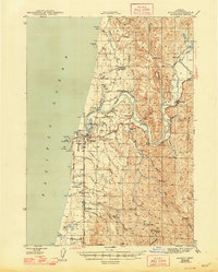
1944 Map of Bandon
USGS Topo · Published 1948About this map
The Coquille River defines the landscape of this coastal Oregon region during the early 1940s, serving as a vital artery for the timber and fishing industries that supported towns like Bandon and Riverton. Along its banks, the map records industrial and maritime infrastructure including the Coquille River Lh and the Ore Fish Hatchery. The interior is marked by a complex network of sloughs and creeks, such as Beaver Slough and Hatchet Slough, which were essential for logging and transport before the extensive modernization of the Oregon Coast Highway.
Find a feature on this map
64 named features on this map. Tap any name to fly to it.
Don’t see what you’re looking for? This feature index may not catch every label — zoom into the map to look around manually.
Map Details
Editions of this 1944 Bandon Map
2 editions found

Other maps of this area

1896 · Coos Bay
USGS Topo · 1:125,000

1898 · Coos Bay
USGS Topo · 1:125,000

1899 · Port Orford
USGS Topo · 1:125,000

1900 · Coos Bay
USGS Topo · 1:125,000

1903 · Port Orford
USGS Topo · 1:125,000

1942 · Empire
USGS Topo · 1:62,500

1942 · Coquille
USGS Topo · 1:62,500

1942 · Coos Bay
USGS Topo · 1:62,500

1943 · Bandon
USGS Topo · 1:62,500

1944 · Empire
USGS Topo · 1:62,500