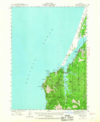
1942 Map of Empire
USGS Topo · Published 1967About this map
The coastal community of Empire and the intricate waterways of Coos Bay define this wartime-era survey of the Oregon coastline. The landscape is a complex network of tidal inlets and ranching property, including the Oldland Ranch and Sengstacken Ranch situated among the deep drainages of South Slough. Naval and maritime interests are evident through the Coast Guard Station and the Arago Lighthouse perched on the rocky headlands of Cape Arago.
Find a feature on this map
62 named features on this map. Tap any name to fly to it.
Don’t see what you’re looking for? This feature index may not catch every label — zoom into the map to look around manually.
Map Details
Editions of this 1942 Empire Map
2 editions found
Other maps of this area

1896 · Coos Bay
USGS Topo · 1:125,000

1898 · Coos Bay
USGS Topo · 1:125,000

1900 · Coos Bay
USGS Topo · 1:125,000

1923 · Reedsport
USGS Topo · 1:62,500

1942 · Reedsport
USGS Topo · 1:62,500

1942 · Empire
USGS Topo · 1:62,500

1942 · Coquille
USGS Topo · 1:62,500

1942 · Coos Bay
USGS Topo · 1:62,500

1943 · Bandon
USGS Topo · 1:62,500

1944 · Empire
USGS Topo · 1:62,500