
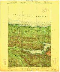
1963 Map of Copalis Beach
USGS Topo · Published 1963About this map
The Quinault Indian Reservation and the protected lands of Olympic National Park dominate this coastal expanse, where the rugged Pacific shoreline meets dense timberlands in the early 1960s. The map illustrates a landscape shaped by powerful river systems including the Quillayute River, Hoh River, and Quinault River, each flowing from the Olympic interior toward the sea. Inland, the town of Forks is a notable hub, served by the Forks Cemetery and surrounded by the Olympic National Forest.
Find a feature on this map
80 named features on this map. Tap any name to fly to it.
Don’t see what you’re looking for? This feature index may not catch every label — zoom into the map to look around manually.
Map Details
Editions of this 1963 Copalis Beach Map
This is the sole edition of this map. No revisions or reprints were ever made.
Other maps of this area

1918 · Lake Crescent
USGS Topo · 1:62,500

1919 · Astoria
USGS Topo · 1:62,500

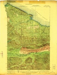
1921 · Quinault Lake
USGS Topo · 1:62,500
1922 · Pysht
USGS Topo · 1:62,500
1922 · Lake Crescent
USGS Topo · 1:62,500

1935 · Ozette Lake
USGS Topo · 1:62,500

1935 · Lake Pleasant
USGS Topo · 1:62,500

1938 · Cape Disappointment
USGS Topo · 1:62,500

1938 · Cape Shoalwater
USGS Topo · 1:62,500

1938 · Fort Columbia
USGS Topo · 1:62,500