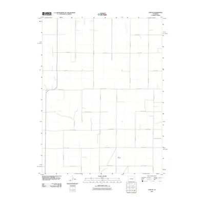
2010 Map of Cope SE
USGS Topo · Published 2010About this map
Smit Cemetery stands as a quiet landmark in this corner of Yuma County, marking a local point of reference within a vast, organized grid of rural infrastructure. The landscape is defined by its rigorous sectional survey lines, with nearly every mile marked by an arterial or local connector, including County Hwy-1 and County Road RR. This 2010 survey illustrates the deep-seated reliance on the county road system for agricultural transport and local connectivity. Small drainages and intermittent water features occasionally break the geometry of the road network, which includes distinct corridors such as County Road NN and County Road LL. The map provides a detailed view of the regional rural layout, showing how early settlement patterns and property lines continue to dictate the modern navigational framework of Eastern Colorado.
Find a feature on this map
24 named features on this map. Tap any name to fly to it.
Don’t see what you’re looking for? This feature index may not catch every label — zoom into the map to look around manually.
Map Details
Editions of this 2010 Cope SE Map
This is the sole edition of this map. No revisions or reprints were ever made.
Other maps of this area

1954 · Limon
USGS Topo · 1:250,000

1957 · Limon
USGS Topo · 1:250,000

1958 · Limon
USGS Topo · 1:250,000

1968 · Joes
USGS Topo · 1:24,000

1977 · Cope
USGS Topo · 1:24,000

1977 · Cope SE
USGS Topo · 1:24,000

1977 · Cope SW
USGS Topo · 1:24,000
1978 · Cope NW
USGS Topo · 1:24,000
1978 · Joes SW
USGS Topo · 1:24,000

1979 · Seibert NE
USGS Topo · 1:24,000