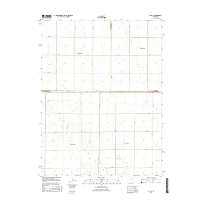
2016 Map of Cope SE
USGS Topo · Published 2016About this map
The high plains of eastern Colorado converge at a triple point of county boundaries on this sheet, where Washington, Yuma, and Kit Carson counties meet. This arid landscape is defined by a rigorous section-line road grid, including Co Rd 3 and Co Rd Aaa, which partitions the terrain into large agricultural blocks typical of the region's ranching and dry-farming heritage. A singular point of genealogical interest, the Smit Cem, sits in the southeastern quadrant near the junction of Co Rd Mm and Co RD 21. The map reveals a sparsely populated area where the economy is etched into the earth through isolated water tanks and a network of county roads like Co Rd Pp and Co Rd Ll that navigate the subtle topographic rises and depressions of the Great Plains.
Find a feature on this map
27 named features on this map. Tap any name to fly to it.
Don’t see what you’re looking for? This feature index may not catch every label — zoom into the map to look around manually.
Map Details
Editions of this 2016 Cope SE Map
This is the sole edition of this map. No revisions or reprints were ever made.
Other maps of this area

1954 · Limon
USGS Topo · 1:250,000

1957 · Limon
USGS Topo · 1:250,000

1958 · Limon
USGS Topo · 1:250,000

1968 · Joes
USGS Topo · 1:24,000

1977 · Cope
USGS Topo · 1:24,000

1977 · Cope SE
USGS Topo · 1:24,000

1977 · Cope SW
USGS Topo · 1:24,000
1978 · Cope NW
USGS Topo · 1:24,000
1978 · Joes SW
USGS Topo · 1:24,000

1979 · Seibert NE
USGS Topo · 1:24,000