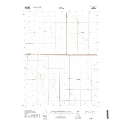
2019 Map of Cope SE
USGS Topo · Published 2019About this map
The high plains intersection of Yuma, Washington, and Kit Carson counties is defined by a rhythmic grid of rural roads and the vast agricultural landscape of eastern Colorado. This 2019 survey captures the strictly organized Public Land Survey System, featuring township lines such as t5s r49w and t6s r48w. The terrain is lightly rolling, punctuated by numerous small depressions and drainage patterns typical of this semi-arid region. Central to the area’s local history is Smit Cem, a solitary landmark near Co Rd Ll and Co Rd 19. The map details a web of secondary transport routes, including Co Rd Aaa and Co Rd 2, which facilitate the movement of goods and people across these expansive county borders. This modern topographic record preserves the enduring section-line road network that has structured Colorado's agricultural heartland for over a century.
Find a feature on this map
29 named features on this map. Tap any name to fly to it.
Don’t see what you’re looking for? This feature index may not catch every label — zoom into the map to look around manually.
Map Details
Editions of this 2019 Cope SE Map
This is the sole edition of this map. No revisions or reprints were ever made.
Other maps of this area

1954 · Limon
USGS Topo · 1:250,000

1957 · Limon
USGS Topo · 1:250,000

1958 · Limon
USGS Topo · 1:250,000

1968 · Joes
USGS Topo · 1:24,000

1977 · Cope
USGS Topo · 1:24,000

1977 · Cope SE
USGS Topo · 1:24,000

1977 · Cope SW
USGS Topo · 1:24,000
1978 · Cope NW
USGS Topo · 1:24,000
1978 · Joes SW
USGS Topo · 1:24,000

1979 · Seibert NE
USGS Topo · 1:24,000