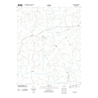
2010 Map of Copeland
USGS Topo · Published 2010About this map
The Fisher River winds southward through this 2010 survey of Surry County, eventually joining the Yadkin River at the historic river crossing of Rockford. This landscape is defined by its rural settlements and a network of secondary roads such as Old Colonial Trl and W Mount Herman Church Rd, which link established communities like Crutchfield and Stony Knoll. The distribution of family and community burial grounds, including Bear Creek Cemetery and Liberty Cemetery, points to the long-standing genealogical roots of the area.
Find a feature on this map
85 named features on this map. Tap any name to fly to it.
Don’t see what you’re looking for? This feature index may not catch every label — zoom into the map to look around manually.
Map Details
Editions of this 2010 Copeland Map
This is the sole edition of this map. No revisions or reprints were ever made.
Other maps of this area

1891 · Yadkinville
USGS Topo · 1:125,000

1893 · Yadkinville
USGS Topo · 1:125,000

1953 · Winston-Salem
USGS Topo · 1:250,000

1955 · Winston-Salem
USGS Topo · 1:250,000

1962 · Winston-Salem
USGS Topo · 1:250,000

1966 · Yadkinville
USGS Topo · 1:24,000

1966 · East Bend
USGS Topo · 1:24,000
1970 · Siloam
USGS Topo · 1:24,000

1970 · Copeland
USGS Topo · 1:24,000
1970 · Mount Airy South
USGS Topo · 1:24,000