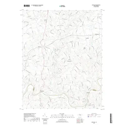
2019 Map of Copeland
USGS Topo · Published 2019About this map
The Fisher River and its numerous tributaries, including Little Beaver Cr and Cody Cr, carve through the rolling landscape of Surry and Yadkin Counties. This 2019 survey captures a series of interconnected rural communities and crossroads, from the town of Dobson in the north to the riverbank settlement of Rockford in the south. The agricultural and residential character of the region is evident in the dense network of local roads such as Brindle Rd and Stanley Mill Rd. Genealogy researchers can find several localized burial grounds and religious sites, including the Copeland Baptist Church Cem and Liberty Cem, which anchor the community of Copeland. In the southwest, the Yadkin River forms a significant boundary near Crutchfield, while the Fairview Wildlife area provides a dedicated space for conservation amidst the patchwork of private landholdings.
Find a feature on this map
151 named features on this map. Tap any name to fly to it.
Don’t see what you’re looking for? This feature index may not catch every label — zoom into the map to look around manually.
Map Details
Editions of this 2019 Copeland Map
This is the sole edition of this map. No revisions or reprints were ever made.
Other maps of this area

1891 · Yadkinville
USGS Topo · 1:125,000

1893 · Yadkinville
USGS Topo · 1:125,000

1953 · Winston-Salem
USGS Topo · 1:250,000

1955 · Winston-Salem
USGS Topo · 1:250,000

1962 · Winston-Salem
USGS Topo · 1:250,000

1966 · Yadkinville
USGS Topo · 1:24,000

1966 · East Bend
USGS Topo · 1:24,000
1970 · Siloam
USGS Topo · 1:24,000

1970 · Copeland
USGS Topo · 1:24,000
1970 · Mount Airy South
USGS Topo · 1:24,000