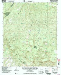
2004 Map of Copper Mountain
USGS Topo · Published 2006About this map
Sierra Ancha and the Salome Wilderness dominate this high-desert landscape within the Tonto National Forest. The map reflects a region of significant elevation changes, defined by the towering presence of Greenback Peak and the deep clefts of Cataract Canyon and Indian Camp Canyon. This early 21st-century revision reveals a landscape primarily dedicated to cattle ranching and wilderness preservation, where remote outposts like the Z T Ranch, J Slash X Ranch, and J R Ranch are positioned near vital water sources.
Find a feature on this map
76 named features on this map. Tap any name to fly to it.
Don’t see what you’re looking for? This feature index may not catch every label — zoom into the map to look around manually.
Map Details
Editions of this 2004 Copper Mountain Map
This is the sole edition of this map. No revisions or reprints were ever made.
Other maps of this area

1886 · Holbrook
USGS Topo · 1:250,000

1887 · Verde
USGS Topo · 1:250,000

1892 · Verde
USGS Topo · 1:250,000

1893 · Holbrook
USGS Topo · 1:250,000

1907 · Roosevelt
USGS Topo · 1:125,000

1909 · Four Peaks
USGS Topo · 1:125,000

1912 · Roosevelt
USGS Topo · 1:125,000

1922 · Chrysotile
USGS Topo · 1:125,000

1937 · Diamond Butte
USGS Topo · 1:48,000

1943 · Diamond Butte
USGS Topo · 1:62,500