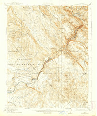
1916 Map of Copperopolis
USGS Topo · Published 1939About this map
The industrial and ranching legacy of the Sierra Nevada foothills is clearly visible in this survey, where the Stanislaus River carves a deep canyon between Gopher Ridge and Table Mountain. Centered on the copper mining hub of Copperopolis, the map illustrates a landscape transitioning from the frantic mineral extraction of the 19th century to early 20th-century infrastructure developments. Evidence of the region's mining heritage is found at the Wilbur-Womble Mine and Napoleon Mine, while the growing need for water management and transit is marked by Goodwin Dam and the winding Sierra Ry of California.
Find a feature on this map
95 named features on this map. Tap any name to fly to it.
Don’t see what you’re looking for? This feature index may not catch every label — zoom into the map to look around manually.
Map Details
Editions of this 1916 Copperopolis Map
3 editions found

Other maps of this area

1889 · Jackson
USGS Topo · 1:125,000

1891 · Big Trees
USGS Topo · 1:125,000

1892 · Jackson
USGS Topo · 1:125,000

1893 · Sonora
USGS Topo · 1:125,000

1894 · Big Trees
USGS Topo · 1:125,000

1896 · Sonora
USGS Topo · 1:125,000

1897 · Jackson
USGS Topo · 1:125,000

1897 · Sonora
USGS Topo · 1:125,000

1897 · Big Trees
USGS Topo · 1:125,000

1898 · Sonora
USGS Topo · 1:125,000
Featured Places
- Telegraph City, CA
- The Shores of Poker Flat, CA
- Copper Cove Subdivision, CA
- Copper Cove Village, CA
- Copperopolis, CA