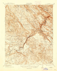
1916 Map of Copperopolis
USGS Topo · Published 1947About this map
The copper-rich hills of Calaveras County define this landscape during the mid-1910s, centering on the mining hub of Copperopolis. The terrain is marked by industrial activity and historical land grants, notably the Rancheria Del Rio Estanislao, which stretches across the southern portion of the sheet. Mining operations like the Wilbur-Womble Mine near Hodson and the Napoleon Mine illustrate the region's extraction-based economy. The Stanislaus River serves as a critical geographic and administrative boundary, carved by steep canyons and crossed by historic transit points such as O'Byrnes Ferry and Central Ferry.
Find a feature on this map
88 named features on this map. Tap any name to fly to it.
Don’t see what you’re looking for? This feature index may not catch every label — zoom into the map to look around manually.
Map Details
Editions of this 1916 Copperopolis Map
3 editions found

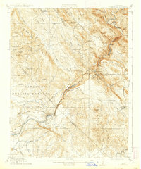
Other maps of this area

1889 · Jackson
USGS Topo · 1:125,000

1891 · Big Trees
USGS Topo · 1:125,000

1892 · Jackson
USGS Topo · 1:125,000

1893 · Sonora
USGS Topo · 1:125,000

1894 · Big Trees
USGS Topo · 1:125,000

1896 · Sonora
USGS Topo · 1:125,000

1897 · Jackson
USGS Topo · 1:125,000

1897 · Sonora
USGS Topo · 1:125,000

1897 · Big Trees
USGS Topo · 1:125,000

1898 · Sonora
USGS Topo · 1:125,000
Featured Places
- Telegraph City, CA
- The Shores of Poker Flat, CA
- Copper Cove Subdivision, CA
- Copper Cove Village, CA
- Copperopolis, CA