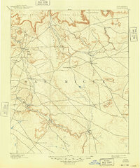
1892 Map of Corazon
USGS Topo · Published 1948About this map
Chaperito and several small adobe-era settlements sit at the heart of this high-plateau landscape, where the Gallinas River and Conchas River carve through a series of expansive mesas. Surveyed in 1890, the map shows a network of trails and primitive roads connecting isolated communities like Aguila, La Junta, and Las Colomas. The geography is defined by prominent landforms such as Yegua Mesa and Mesa Montosa, which rise above the river valleys and arroyos.
Find a feature on this map
38 named features on this map. Tap any name to fly to it.
Don’t see what you’re looking for? This feature index may not catch every label — zoom into the map to look around manually.
Map Details
Editions of this 1892 Corazon Map
2 editions found
Other maps of this area

1889 · Las Vegas
USGS Topo · 1:125,000

1890 · Bernal
USGS Topo · 1:125,000

1891 · Bernal
USGS Topo · 1:125,000

1891 · Las Vegas
USGS Topo · 1:125,000

1892 · Watrous
USGS Topo · 1:125,000

1892 · Corazon
USGS Topo · 1:125,000

1893 · Las Vegas
USGS Topo · 1:125,000

1894 · Corazon
USGS Topo · 1:125,000

1894 · Watrous
USGS Topo · 1:125,000

1894 · Bernal
USGS Topo · 1:125,000