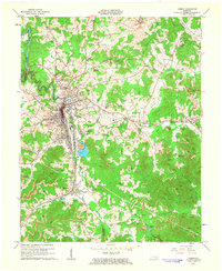
1961 Map of Corbin
USGS Topo · Published 1963About this map
The Louisville and Nashville railroad corridor serves as the industrial and social backbone for this portion of Whitley, Knox, and Laurel Counties in the early 1960s. At the heart of the region, Corbin is a dense center of activity, featuring the St Camillus Academy and Ward Sch, alongside essential infrastructure like the local Hospital and Sewage Disposal. Outside the city center, the landscape transitions into a heavy industrial zone marked by numerous Strip Mine operations and individual Mine sites, particularly near the settlement of Wilton.
Find a feature on this map
69 named features on this map. Tap any name to fly to it.
Don’t see what you’re looking for? This feature index may not catch every label — zoom into the map to look around manually.
Map Details
Editions of this 1961 Corbin Map
This is the sole edition of this map. No revisions or reprints were ever made.
Other maps of this area

1886 · Cumberland Gap
USGS Topo · 1:125,000

1888 · Cumberland Gap
USGS Topo · 1:125,000

1890 · Williamsburg
USGS Topo · 1:125,000

1891 · Manchester
USGS Topo · 1:125,000

1891 · Cumberland Gap
USGS Topo · 1:125,000

1893 · London
USGS Topo · 1:125,000

1894 · Williamsburg
USGS Topo · 1:125,000

1897 · London
USGS Topo · 1:125,000

1952 · Corbin
USGS Topo · 1:24,000

1952 · Wofford
USGS Topo · 1:24,000