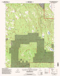
1995 Map of Corders Reservoir
USGS Topo · Published 1997About this map
The Blacks Mountain Experimental Forest and surrounding Lassen National Forest terrain dominate this 1990s survey, illustrating a landscape managed for research and conservation. The presence of the State Game Refuge and the Old Railroad Grade suggests a history of both natural resource protection and earlier industrial access. Historically significant locations like the Eldridge Homestead (Site) and Blacks Cabin Flat provide concrete points of interest for genealogists and local historians tracing early 20th-century occupancy in the high country.
Find a feature on this map
38 named features on this map. Tap any name to fly to it.
Don’t see what you’re looking for? This feature index may not catch every label — zoom into the map to look around manually.
Map Details
Editions of this 1995 Corders Reservoir Map
This is the sole edition of this map. No revisions or reprints were ever made.
Other maps of this area

1886 · Lassen Peak
USGS Topo · 1:250,000

1892 · Lassen Peak
USGS Topo · 1:250,000

1894 · Lassen Peak
USGS Topo · 1:250,000

1939 · Halls Flat
USGS Topo · 1:125,000

1955 · Westwood
USGS Topo · 1:250,000

1956 · Harvey Mtn
USGS Topo · 1:62,500

1957 · Prospect Peak
USGS Topo · 1:62,500

1957 · Little Valley
USGS Topo · 1:62,500

1957 · Jellico
USGS Topo · 1:62,500

1958 · Westwood
USGS Topo · 1:250,000