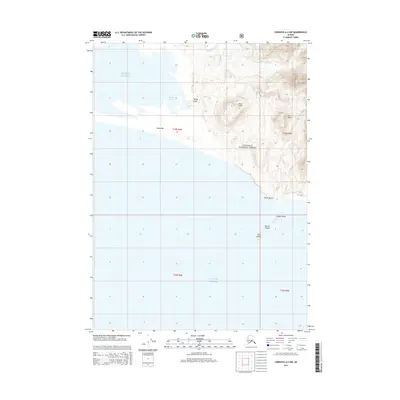
2014 Map of Cordova A-2 NW
USGS Topo · Published 2014About this map
Chugach National Forest meets the northern reaches of the Gulf of Alaska in this coastal survey, where the dynamic interface of silt and sea is evident in the formation of Softuk Bar and the sheltered waters of Softuk Lagoon. The coastal topography is defined by prominent elevations like Mount Lazier and Lone Baldy, which rise sharply from the shoreline to overlook the intricate drainage of Mirror Slough. To the south, a cluster of named landforms including Whale Island, the Martin Islands, and Fox Island dot the waters near Point Martin, marking significant navigational landmarks along this wild stretch of the Alaskan coastline. This survey documents the natural boundary between the high timberlands and the shifting sediments of the Gulf, capturing a landscape dominated by tidal action and glacial runoff.
Find a feature on this map
17 named features on this map. Tap any name to fly to it.
Don’t see what you’re looking for? This feature index may not catch every label — zoom into the map to look around manually.
Map Details
Editions of this 2014 Cordova A-2 NW Map
This is the sole edition of this map. No revisions or reprints were ever made.
Other maps of this area

1948 · Cordova
USGS Topo · 1:250,000

1950 · Cordova B-2
USGS Topo · 1:63,360

1950 · Cordova A-2
USGS Topo · 1:63,360

1951 · Cordova
USGS Topo · 1:250,000

1952 · Cordova B-3
USGS Topo · 1:63,360

1953 · Cordova A-2
USGS Topo · 1:63,360

1953 · Cordova B-2
USGS Topo · 1:63,360

1953 · Cordova B-3
USGS Topo · 1:63,360

1959 · Cordova
USGS Topo · 1:250,000
1988 · Cordova A-3
USGS Topo · 1:63,360