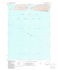
1988 Map of Cordova A-3
USGS Topo · Published 1988About this map
The Copper River Delta dominates this coastal survey, where the river's massive sediment output meets the churning waters of the Gulf of Alaska. By the late 1980s, this area was formally recognized as the Copper River Delta State Critical Habitat Area, a designation reflecting the complex wetland ecology of the shoreline. The map documents the shifting sands of Strawberry Reef, a notable maritime feature at the river's mouth. Much of the sheet covers the deep waters of the Pacific Ocean, marked by an Indefinite Boundary and detailed bathymetric soundings that reveal the underwater topography of the continental shelf. This is a landscape of constant flux, where the interplay of glacial silt and oceanic tides creates a dynamic and uninhabited coastal margin.
Find a feature on this map
6 named features on this map. Tap any name to fly to it.
Don’t see what you’re looking for? This feature index may not catch every label — zoom into the map to look around manually.
Map Details
Editions of this 1988 Cordova A-3 Map
This is the sole edition of this map. No revisions or reprints were ever made.
Other maps of this area

1948 · Cordova
USGS Topo · 1:250,000

1948 · Middleton Island
USGS Topo · 1:250,000

1950 · Middleton Island
USGS Topo · 1:250,000

1950 · Cordova B-2
USGS Topo · 1:63,360

1950 · Cordova A-2
USGS Topo · 1:63,360

1951 · Cordova
USGS Topo · 1:250,000

1951 · Cordova B-4
USGS Topo · 1:63,360

1952 · Cordova B-3
USGS Topo · 1:63,360

1953 · Cordova A-2
USGS Topo · 1:63,360

1953 · Cordova B-2
USGS Topo · 1:63,360