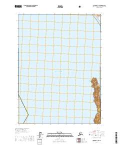
2017 Map of Cordova A-2 SE
USGS Topo · Published 2017About this map
Wingham Island stands as a prominent coastal feature along the eastern edge of the Gulf of Alaska, marking the transition between open sea and the sheltered Okalee Channel. This maritime landscape, captured in 2017, is largely defined by the protected territory of the Chugach National Forest, which covers the island's terrain. The map illustrates the specialized geography of the Valdez-Cordova Census Area, where terrestrial landforms are few and concentrated on the eastern margin. The intricate contouring on Wingham Island suggests a steep, elevated landmass rising abruptly from the surrounding waters, a characteristic of the coastal topography in this region of Alaska.
Find a feature on this map
10 named features on this map. Tap any name to fly to it.
Don’t see what you’re looking for? This feature index may not catch every label — zoom into the map to look around manually.
Map Details
Editions of this 2017 Cordova A-2 SE Map
This is the sole edition of this map. No revisions or reprints were ever made.
Other maps of this area

1948 · Cordova
USGS Topo · 1:250,000

1948 · Middleton Island
USGS Topo · 1:250,000

1950 · Middleton Island
USGS Topo · 1:250,000

1950 · Cordova A-1
USGS Topo · 1:63,360

1950 · Cordova A-2
USGS Topo · 1:63,360

1951 · Cordova
USGS Topo · 1:250,000

1953 · Cordova A-2
USGS Topo · 1:63,360
1953 · Cordova A-1
USGS Topo · 1:63,360
1955 · Middleton Island D-1 and D-2
USGS Topo · 1:63,360
1955 · Middleton Island
USGS Topo · 1:250,000