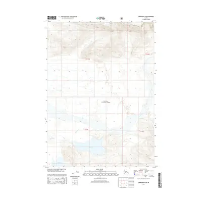
2014 Map of Cordova B-2 NE
USGS Topo · Published 2014About this map
Chugach National Forest encompasses the vast majority of this 2014 Alaskan landscape, where the shifting hydrology of the Martin River corridor defines the terrain. The glacial-fed waters of Martin Lake and the smaller Little Martin Lake dominate the southern lowlands, fed by complex braided streams and smaller tributaries like Tokun Cr. The map illustrates a transitional environment where the river channels meander through broad alluvial flats before rising into the steep, unnamed ridgelines of the northern Chugach Range. Surveyed by the U.S. Geological Survey, this sheet captures a wilderness area devoid of modern infrastructure or permanent settlements, focusing instead on the precise natural contours and water systems of the Unorganized Borough in the early 21st century.
Find a feature on this map
9 named features on this map. Tap any name to fly to it.
Don’t see what you’re looking for? This feature index may not catch every label — zoom into the map to look around manually.
Map Details
Editions of this 2014 Cordova B-2 NE Map
This is the sole edition of this map. No revisions or reprints were ever made.
Other maps of this area

1948 · Cordova
USGS Topo · 1:250,000

1950 · Cordova B-2
USGS Topo · 1:63,360

1951 · Cordova
USGS Topo · 1:250,000

1951 · Cordova B-1
USGS Topo · 1:63,360

1953 · Cordova B-1
USGS Topo · 1:63,360

1953 · Cordova B-2
USGS Topo · 1:63,360

1959 · Cordova C-2
USGS Topo · 1:63,360

1959 · Cordova C-1
USGS Topo · 1:63,360

1959 · Cordova
USGS Topo · 1:250,000
1997 · Cordova B-2
USGS Topo · 1:63,360