
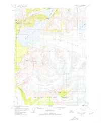
1959 Map of Cordova C-2
USGS Topo · Published 1963About this map
The Million Dollar Bridge stands as a massive engineering landmark where the Old Railroad Grade meets the churning waters of the Copper River. This 1959 field-annotated map captures a landscape dominated by massive ice and water, where the river forces its way through Baird Canyon and creates the turbulent Abercrombie Rapids. The survey documents the remnants of the Copper River and Northwestern Railway, showing the transit route skirting the shores of Miles Lake and navigating the narrow corridor between towering peaks and active glaciers.
Find a feature on this map
18 named features on this map. Tap any name to fly to it.
Don’t see what you’re looking for? This feature index may not catch every label — zoom into the map to look around manually.
Map Details
Editions of this 1959 Cordova C-2 Map
2 editions found
Other maps of this area

1948 · Cordova
USGS Topo · 1:250,000

1950 · Cordova B-2
USGS Topo · 1:63,360

1950 · Cordova D-3
USGS Topo · 1:63,360

1951 · Cordova
USGS Topo · 1:250,000

1951 · Cordova B-1
USGS Topo · 1:63,360

1951 · Cordova C-3
USGS Topo · 1:63,360

1952 · Cordova B-3
USGS Topo · 1:63,360

1953 · Cordova B-1
USGS Topo · 1:63,360

1953 · Cordova C-3
USGS Topo · 1:63,360

1953 · Cordova B-2
USGS Topo · 1:63,360