
1951 Map of Cordova C-3
USGS Topo · Published 1965About this map
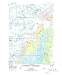
Copper River flows into its expansive braided delta at the foot of the southern Chugach Mountains, dominating the eastern portion of this mid-century topographic record. The landscape is defined by massive glacial systems, including the Scott Glacier, Sheridan Glacier, and Childs Glacier, all marked with detailed indications of crevasses that reveal the active movement of these ice fields. Peaks such as Mt Williams and Mt O'Neel rise sharply from the ice, serving as anchors for the Chugach National Forest Boundary that spans the terrain. This survey provides a specific look at the drainage patterns and shoreline morphology of the Copper River Delta as it existed in 1951, showing the intricate network of channels around Long Island before more modern geological shifts.
Find a feature on this map
21 named features on this map. Tap any name to fly to it.
Don’t see what you’re looking for? This feature index may not catch every label — zoom into the map to look around manually.
Map Details
Editions of this 1951 Cordova C-3 Map
2 editions found
Other maps of this area

1948 · Cordova
USGS Topo · 1:250,000

1950 · Cordova B-2
USGS Topo · 1:63,360

1950 · Cordova C-4
USGS Topo · 1:63,360

1950 · Cordova D-3
USGS Topo · 1:63,360

1951 · Cordova
USGS Topo · 1:250,000

1951 · Cordova B-4
USGS Topo · 1:63,360

1951 · Cordova D-4
USGS Topo · 1:63,360

1952 · Cordova B-3
USGS Topo · 1:63,360

1953 · Cordova D-4
USGS Topo · 1:63,360

1953 · Cordova C-3
USGS Topo · 1:63,360