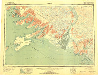
1953 Map of Cordova D-4
USGS Topo · Published 1954About this map
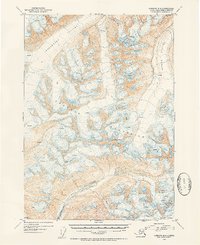
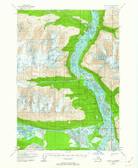
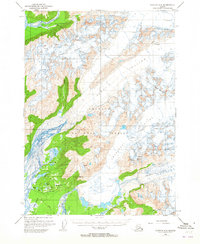
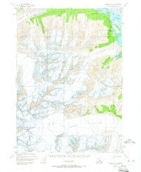
The Chugach Mountains dominate this 1953 survey, a landscape defined by massive ice sheets and heavy glaciation within the Chugach Nat Forest. The map documents the intricate surface of the Woodworth Glacier and Schwan Glacier, with numerous crevasses explicitly marked across the ice fields. Rising to a prominent point in the center of the sheet, Cordova Peak serves as a primary landmark above the frozen terrain. In the lower portion of the quadrangle, the drainage of the Rude River carves through the southern slopes, providing a stark contrast to the high-elevation glacial environment. This map is a significant record of mid-century Alaskan glaciology, illustrating the extent and flow patterns of major coastal glaciers before decades of modern retreat. It also includes the geodetic control point VABM Worth 3789 near the northern boundary.
Find a feature on this map
8 named features on this map. Tap any name to fly to it.
Don’t see what you’re looking for? This feature index may not catch every label — zoom into the map to look around manually.
Map Details
Editions of this 1953 Cordova D-4 Map
2 editions found

Other maps of this area

1948 · Cordova
USGS Topo · 1:250,000
1950 · Valdez A-3
USGS Topo · 1:63,360
1950 · Cordova C-4
USGS Topo · 1:63,360
1950 · Cordova D-3
USGS Topo · 1:63,360

1950 · Cordova D-5
USGS Topo · 1:63,360
1951 · Cordova
USGS Topo · 1:250,000
1951 · Cordova C-5
USGS Topo · 1:63,360
1951 · Cordova C-3
USGS Topo · 1:63,360

1951 · Cordova D-4
USGS Topo · 1:63,360

1952 · Valdez
USGS Topo · 1:250,000