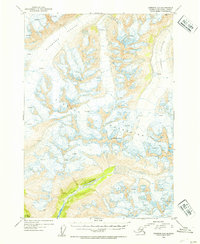
1953 Map of Cordova D-4
USGS Topo · Published 1954About this map
Cordova Peak and the high ridges of the Chugach Mountains dominate this 1953 topographic study, revealing a landscape defined by massive ice fields and active glaciation. Deep within the Chugach Nat Forest, the map traces the sprawling paths of the Woodworth Glacier and Schwan Glacier, where dense clusters of crevasses indicate the constant movement of the ice. The drainage patterns of the era are clearly visible as meltwater feeds the Rude River, which carves a path through the southern reaches of the quadrangle. For those studying the glaciology and alpine geography of the Alaska-Third Judicial Division during the mid-twentieth century, the map provides precise elevation data for summits such as VABM Worth 3789, preserving the exact state of these mountain features before decades of modern glacial recession.
Find a feature on this map
8 named features on this map. Tap any name to fly to it.
Don’t see what you’re looking for? This feature index may not catch every label — zoom into the map to look around manually.
Map Details
Editions of this 1953 Cordova D-4 Map
2 editions found

Other maps of this area

1948 · Cordova
USGS Topo · 1:250,000

1950 · Valdez A-3
USGS Topo · 1:63,360

1950 · Cordova C-4
USGS Topo · 1:63,360

1950 · Cordova D-3
USGS Topo · 1:63,360

1950 · Cordova D-5
USGS Topo · 1:63,360

1951 · Cordova
USGS Topo · 1:250,000

1951 · Cordova C-5
USGS Topo · 1:63,360

1951 · Cordova C-3
USGS Topo · 1:63,360

1951 · Cordova D-4
USGS Topo · 1:63,360

1952 · Valdez
USGS Topo · 1:250,000