
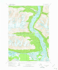
1950 Map of Valdez A-3
USGS Topo · Published 1962About this map
The Copper River and Northwestern Railroad corridor defines this mid-century topographic record, tracing the eastern bank of the massive Copper River delta. Based on aerial photography from 1950, the sheet captures a landscape dominated by the movement of ice and water, where the Schwan Glacier feeds into the broad, braided valley of the Tasnuna River. The intricate river systems, including the Tiekel River and numerous tributaries like Thunder Creek and Cleave Creek, illustrate the complex drainage patterns found south of the central Chugach Mountains.
Find a feature on this map
10 named features on this map. Tap any name to fly to it.
Don’t see what you’re looking for? This feature index may not catch every label — zoom into the map to look around manually.
Map Details
Editions of this 1950 Valdez A-3 Map
2 editions found
Other maps of this area

1948 · Cordova
USGS Topo · 1:250,000

1950 · Cordova D-3
USGS Topo · 1:63,360

1951 · Cordova
USGS Topo · 1:250,000

1951 · Valdez B-2
USGS Topo · 1:63,360

1951 · Valdez B-3
USGS Topo · 1:63,360

1951 · Valdez B-4
USGS Topo · 1:63,360

1951 · Cordova D-4
USGS Topo · 1:63,360

1951 · Valdez A-2
USGS Topo · 1:63,360

1952 · Valdez
USGS Topo · 1:250,000

1953 · Cordova D-4
USGS Topo · 1:63,360