
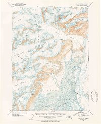
1953 Map of Cordova C-3
USGS Topo · Published 1954About this map
The Copper River dominates this mid-century Alaskan landscape, its braided channels spreading across the Copper River Delta as it flows south through the Chugach Mountains. The map captures a transition in transportation history, clearly marking an Old Railroad Grade running parallel to the river—the remains of the Copper River and Northwestern Railway which once connected the mines at Kennicott to the coast. Near the river's edge, another route is shown as Under Construction, indicating the early development of the Copper River Highway.
Find a feature on this map
21 named features on this map. Tap any name to fly to it.
Don’t see what you’re looking for? This feature index may not catch every label — zoom into the map to look around manually.
Map Details
Editions of this 1953 Cordova C-3 Map
2 editions found
Other maps of this area

1948 · Cordova
USGS Topo · 1:250,000

1950 · Cordova B-2
USGS Topo · 1:63,360

1950 · Cordova C-4
USGS Topo · 1:63,360

1950 · Cordova D-3
USGS Topo · 1:63,360

1951 · Cordova
USGS Topo · 1:250,000

1951 · Cordova B-4
USGS Topo · 1:63,360

1951 · Cordova C-3
USGS Topo · 1:63,360

1951 · Cordova D-4
USGS Topo · 1:63,360

1952 · Cordova B-3
USGS Topo · 1:63,360

1953 · Cordova D-4
USGS Topo · 1:63,360