
1953 Map of Cordova B-1
USGS Topo · Published 1954About this map
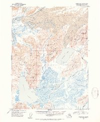
Martin River Glacier dominates the northern reaches of this landscape, its massive ice field marked by deep crevasses that feed a complex network of glacial rivers. The interior is defined by the Chugach National Forest, where the presence of Carbon Camp and several isolated cabins suggests a history of remote resource exploration or seasonal trapping. This wilderness is carved by numerous waterways including Kushtaka Lake and the Bering River, which meanders through vast wetlands before reaching Bering Lake. High mountain ridges like Cunningham Ridge and peaks such as Monument Mtn rise sharply from the valleys, providing a dramatic vertical contrast to the low-lying river deltas. The inclusion of labels like Coal Mine Cr hints at the coal-bearing geology of the Shockum Mountains, while features like Powers Falls and various mineral survey markers like Uslm No 3 provide specific points of reference for local historians and surveyors.
Find a feature on this map
48 named features on this map. Tap any name to fly to it.
Don’t see what you’re looking for? This feature index may not catch every label — zoom into the map to look around manually.
Map Details
Editions of this 1953 Cordova B-1 Map
2 editions found
Other maps of this area

1948 · Cordova
USGS Topo · 1:250,000

1950 · Bering Glacier
USGS Topo · 1:250,000

1950 · Cordova B-2
USGS Topo · 1:63,360

1950 · Cordova A-1
USGS Topo · 1:63,360

1950 · Cordova A-2
USGS Topo · 1:63,360

1951 · Bering Glacier
USGS Topo · 1:250,000

1951 · Cordova
USGS Topo · 1:250,000

1951 · Cordova B-1
USGS Topo · 1:63,360

1953 · Cordova A-2
USGS Topo · 1:63,360

1953 · Cordova B-2
USGS Topo · 1:63,360