
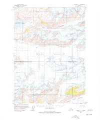
1959 Map of Cordova C-1
USGS Topo · Published 1964About this map
Miles Glacier dominates this mid-century survey of the Chugach Mountains, where immense ice fields define the physical geography of the Alaskan interior. The landscape is characterized by a massive glacial network, including the expansive Van Cleve Glacier and the adjacent Van Cleve Lake. This 1959 field-annotated map provides a look at the frozen terrain within the Chugach National Forest, showing the detailed topography of these moving ice masses and the crevasses that mark their surfaces. The southward flow is further illustrated by the presence of Johnson Glacier and the Martin River Glacier. While the area lacks any established settlements or roads, the map meticulously records the intersection of high-altitude peaks and the frozen river systems that have shaped this portion of the National Forest Boundary.
Find a feature on this map
11 named features on this map. Tap any name to fly to it.
Don’t see what you’re looking for? This feature index may not catch every label — zoom into the map to look around manually.
Map Details
Editions of this 1959 Cordova C-1 Map
2 editions found
Other maps of this area

1948 · Cordova
USGS Topo · 1:250,000

1950 · Bering Glacier
USGS Topo · 1:250,000

1950 · Cordova B-2
USGS Topo · 1:63,360

1951 · Bering Glacier
USGS Topo · 1:250,000

1951 · Cordova
USGS Topo · 1:250,000

1951 · Cordova B-1
USGS Topo · 1:63,360

1953 · Cordova B-1
USGS Topo · 1:63,360

1953 · Cordova B-2
USGS Topo · 1:63,360

1959 · Cordova C-2
USGS Topo · 1:63,360

1959 · Cordova D-1
USGS Topo · 1:63,360