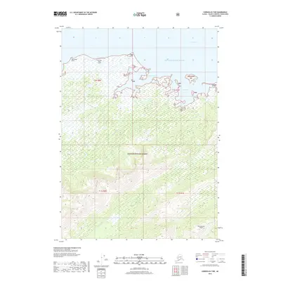
2018 Map of Cordova B-7 NW
USGS Topo · Published 2018About this map
Prince William Sound defines the northern edge of this coastal Alaskan landscape, where the waters of Orca Bay meet the northern reaches of Hinchinbrook Island. The terrain is characterized by a network of drainage systems such as Constantine Cr and Hooker Cr that flow through the dense, protected lands of the Chugach National Forest. On the island's northwestern tip, Johnstone Point serves as a critical geographic marker, accompanied by the Johnstone Point Airport. The coastline is deeply indented by features like Anderson Bay and Double Bay, reflecting the intricate shoreline of the Unorganized Borough. This survey captures the topographical transition from the sea-level marshes and flats near Eagle Point to the elevated interior ridges of the national forest, providing a clear picture of the region's wilderness character and navigational landmarks.
Find a feature on this map
22 named features on this map. Tap any name to fly to it.
Don’t see what you’re looking for? This feature index may not catch every label — zoom into the map to look around manually.
Map Details
Editions of this 2018 Cordova B-7 NW Map
This is the sole edition of this map. No revisions or reprints were ever made.
Other maps of this area

1948 · Cordova
USGS Topo · 1:250,000

1950 · Cordova C-7
USGS Topo · 1:63,360

1950 · Cordova B-7
USGS Topo · 1:63,360

1950 · Cordova C-8
USGS Topo · 1:63,360

1951 · Cordova
USGS Topo · 1:250,000

1951 · Cordova B-8
USGS Topo · 1:63,360

1952 · Cordova C-8
USGS Topo · 1:63,360

1953 · Cordova B-7
USGS Topo · 1:63,360
1953 · Cordova C-7
USGS Topo · 1:63,360
1953 · Cordova B-8
USGS Topo · 1:63,360