
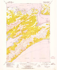
1953 Map of Cordova B-7
USGS Topo · Published 1954About this map
Hinchinbrook Island and Hawkins Island dominate this coastal survey of the Prince William Sound approaches, where the open Gulf of Alaska meets protected inlets. On the western shore of the larger island, Port Etches provides a deep-water indentation leading into Constantine Harbor, marked by Phipps Pt and Pt Horn. This maritime landscape, entirely within the Chugach National Forest, was mapped using 1950 aerial photography to detail the complex shoreline and steep topography. Navigation aids like the Light at Johnstone Point highlight the area's importance as a gateway to Orca Bay. Marine features such as Hawkins Cutoff and the mud flats near Anderson Bay illustrate the intricate tidal and channel systems that defined local passage before further modern development.
Find a feature on this map
17 named features on this map. Tap any name to fly to it.
Don’t see what you’re looking for? This feature index may not catch every label — zoom into the map to look around manually.
Map Details
Editions of this 1953 Cordova B-7 Map
2 editions found
Other maps of this area

1948 · Cordova
USGS Topo · 1:250,000

1950 · Cordova C-7
USGS Topo · 1:63,360

1950 · Cordova C-6
USGS Topo · 1:63,360

1950 · Cordova B-7
USGS Topo · 1:63,360

1950 · Cordova C-8
USGS Topo · 1:63,360

1951 · Cordova
USGS Topo · 1:250,000

1951 · Cordova B-8
USGS Topo · 1:63,360
1951 · Cordova A-7 and A-8
USGS Topo · 1:63,360

1951 · Cordova B-6
USGS Topo · 1:63,360

1952 · Cordova C-8
USGS Topo · 1:63,360