
1951 Map of Cordova B-6
USGS Topo · Published 1976About this map
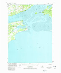
Orca Inlet serves as a central waterway in this coastal survey, dividing the substantial landmasses of Hawkins Island and the mainland. The landscape is defined by the proximity of the Heney Range to the shoreline, where tidal flats like Hartney Bay and extensive mud shoals dictate the navigation patterns of the early 1950s. Near the settlement of Whitshed, the map identifies Canneries and Radio Towers, indicating the industrial and communication infrastructure vital to the region's maritime economy. To the south, Hinchinbrook Island features prominent landmarks such as Strawberry Hill and Pt Bentinck, guarding the entrance to Boswell Bay. The presence of a Radio Range Sta on the island's eastern point underscores the area's significance for regional air and sea navigation during the postwar era. This document preserves the precise shoreline and topographic details before minor revisions altered the recorded coastal profile in later decades.
Find a feature on this map
26 named features on this map. Tap any name to fly to it.
Don’t see what you’re looking for? This feature index may not catch every label — zoom into the map to look around manually.
Map Details
Editions of this 1951 Cordova B-6 Map
3 editions found
Other maps of this area

1948 · Cordova
USGS Topo · 1:250,000

1950 · Cordova C-7
USGS Topo · 1:63,360

1950 · Cordova C-6
USGS Topo · 1:63,360

1950 · Cordova B-7
USGS Topo · 1:63,360

1951 · Cordova
USGS Topo · 1:250,000

1951 · Cordova C-5
USGS Topo · 1:63,360

1951 · Cordova B-5
USGS Topo · 1:63,360

1953 · Cordova C-6
USGS Topo · 1:63,360

1953 · Cordova B-7
USGS Topo · 1:63,360

1953 · Cordova B-5
USGS Topo · 1:63,360