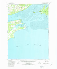
1951 Map of Cordova B-6
USGS Topo · Published 1978About this map
Orca Inlet serves as the central maritime corridor for this coastal region, separating Hawkins Island from the Heney Range on the mainland. The 1951 aerial surveys reveal a landscape defined by seasonal industry and essential coastal navigation, anchored by Canneries at the mouth of Hartney Bay. These operations, paired with the Seaplane Base on Hinchinbrook Island and several radio facilities like the Radio Range Sta, underscore the territory's reliance on air and sea travel before the expansion of permanent road networks. Beyond the industrialized points, the map traces the intricate maze of the Hawkins Island Cutoff and the protected waters of Boswell Bay. Points of navigational importance such as Pt Whitshed and Pt Bentinck mark the transition into the open waters of the Gulf of Alaska, while small landmarks like Strawberry Hill and Mummy I provide orientation for those navigating these frequently silted tidal flats.
Find a feature on this map
41 named features on this map. Tap any name to fly to it.
Don’t see what you’re looking for? This feature index may not catch every label — zoom into the map to look around manually.
Map Details
Editions of this 1951 Cordova B-6 Map
3 editions found
Other maps of this area

1948 · Cordova
USGS Topo · 1:250,000

1950 · Cordova C-7
USGS Topo · 1:63,360

1950 · Cordova C-6
USGS Topo · 1:63,360

1950 · Cordova B-7
USGS Topo · 1:63,360

1951 · Cordova
USGS Topo · 1:250,000

1951 · Cordova C-5
USGS Topo · 1:63,360

1951 · Cordova B-5
USGS Topo · 1:63,360

1951 · Cordova B-6
USGS Topo · 1:63,360

1953 · Cordova C-6
USGS Topo · 1:63,360

1953 · Cordova B-7
USGS Topo · 1:63,360