
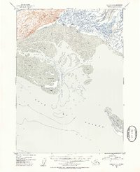
1953 Map of Cordova B-5
USGS Topo · Published 1954About this map
The Heney Range rises sharply above the coastal wetlands in this early 1950s survey of the Chugach National Forest shoreline. This landscape is defined by the complex, shifting hydrology where the Eyak River and Glacier River discharge into the Gulf of Alaska. The map documents a rugged coastal environment transition, from the high peaks near Crystal Falls down to the extensive mud and sand flats of the delta. Human presence is sparse and seasonal, represented by scattered Cabins and Fishing Cabins along the riverbanks. Navigational markers like the Light near the Egg Islands and the deep Egg Island Channel underscore the maritime importance of these waters. Local transit is limited to the Eyak Trail, which skirts the base of the mountains, and various sloughs like Government Slough that wind through the tidal marshes.
Find a feature on this map
17 named features on this map. Tap any name to fly to it.
Don’t see what you’re looking for? This feature index may not catch every label — zoom into the map to look around manually.
Map Details
Editions of this 1953 Cordova B-5 Map
2 editions found
Other maps of this area

1948 · Cordova
USGS Topo · 1:250,000

1950 · Cordova C-6
USGS Topo · 1:63,360

1950 · Cordova C-4
USGS Topo · 1:63,360

1951 · Cordova
USGS Topo · 1:250,000

1951 · Cordova B-4
USGS Topo · 1:63,360

1951 · Cordova C-5
USGS Topo · 1:63,360

1951 · Cordova B-5
USGS Topo · 1:63,360

1951 · Cordova B-6
USGS Topo · 1:63,360

1953 · Cordova C-6
USGS Topo · 1:63,360

1953 · Cordova C-4
USGS Topo · 1:63,360