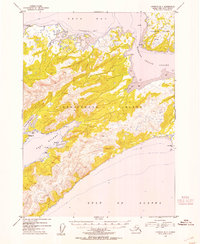
1953 Map of Cordova B-7
USGS Topo · Published 1954About this map
Hinchinbrook Island dominates this coastal survey, serving as a primary maritime barrier between the Gulf of Alaska and the sheltered waters of Orca Bay. The landscape is characterized by its complex shoreline, most notably at Port Etches, where the natural anchorage of Constantine Harbor is protected by Phipps Pt. A single Light at Johnstone Pt marks the western approach to the bay, providing a vital navigational aid for vessels navigating the passage between Hinchinbrook Island and the neighboring Hawkins Island. This area, entirely within the Chugach National Forest, reflects the early 1950s maritime geography of the Prince William Sound region. The intricate Hawkins Island Cutoff and remote inlets like Dan Bay and Garden Cove illustrate the island's isolation and the significance of water-based transport in this Alaskan territory.
Find a feature on this map
18 named features on this map. Tap any name to fly to it.
Don’t see what you’re looking for? This feature index may not catch every label — zoom into the map to look around manually.
Map Details
Editions of this 1953 Cordova B-7 Map
2 editions found

Other maps of this area

1948 · Cordova
USGS Topo · 1:250,000

1950 · Cordova C-7
USGS Topo · 1:63,360

1950 · Cordova C-6
USGS Topo · 1:63,360

1950 · Cordova B-7
USGS Topo · 1:63,360

1950 · Cordova C-8
USGS Topo · 1:63,360

1951 · Cordova
USGS Topo · 1:250,000

1951 · Cordova B-8
USGS Topo · 1:63,360
1951 · Cordova A-7 and A-8
USGS Topo · 1:63,360

1951 · Cordova B-6
USGS Topo · 1:63,360

1952 · Cordova C-8
USGS Topo · 1:63,360