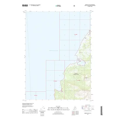
2018 Map of Cordova B-8 NE
USGS Topo · Published 2018About this map
Prince William Sound defines the western expanse of this coastal study, where the waters meet the northwestern shores of Hinchinbrook Island. The terrain is characterized by the high elevations of the Chugach National Forest, which covers the southern landmass and features prominent coastal landmarks. Along the northeast coast, The Seven Sisters stand as a series of distinctive landforms above the shoreline. The island’s irregular coast is carved by small protected waters, including Shelter Bay and Deer Cove, while Shelter Point serves as a navigational marker for those moving through the sound. This map provides a detailed view of the interaction between the deep waters of the sound and the steep, forested slopes of the island before any significant modern development altered the shoreline.
Find a feature on this map
12 named features on this map. Tap any name to fly to it.
Don’t see what you’re looking for? This feature index may not catch every label — zoom into the map to look around manually.
Map Details
Editions of this 2018 Cordova B-8 NE Map
This is the sole edition of this map. No revisions or reprints were ever made.
Other maps of this area

1948 · Cordova
USGS Topo · 1:250,000

1950 · Cordova C-7
USGS Topo · 1:63,360

1950 · Cordova B-7
USGS Topo · 1:63,360

1950 · Cordova C-8
USGS Topo · 1:63,360

1951 · Cordova
USGS Topo · 1:250,000

1951 · Cordova B-8
USGS Topo · 1:63,360

1952 · Cordova C-8
USGS Topo · 1:63,360

1953 · Cordova B-7
USGS Topo · 1:63,360
1953 · Cordova C-7
USGS Topo · 1:63,360
1953 · Cordova B-8
USGS Topo · 1:63,360