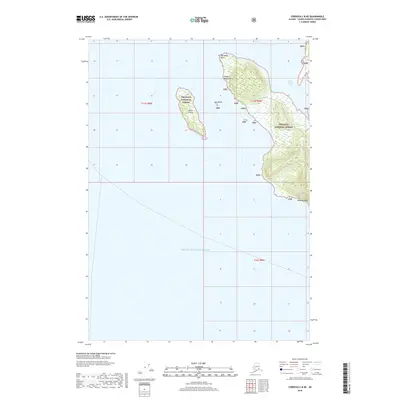
2018 Map of Cordova C-8 NE
USGS Topo · Published 2018About this map
Prince William Sound defines this coastal landscape where the waters meet the rugged edges of the Chugach National Forest. The map focuses on the intricate shoreline and several significant islands, including the elongated Goose Island and the smaller Gull Island situated offshore. Topography is dominated by the western reaches of the Chugach Mountains, which rise sharply from the sea. Maritime landmarks such as Porcupine Point and Knowles Head provide critical navigation points along this isolated stretch of the Alaskan coast. The sheltered waters of Snug Corner Cove offer a distinct contrast to the open sound, illustrating the natural harbors that have historically served as refuge for mariners and local inhabitants in the Valdez-Cordova region. This 2018 survey detail provides a modern record of these landforms before the continuous natural shifts of the coastal environment.
Find a feature on this map
12 named features on this map. Tap any name to fly to it.
Don’t see what you’re looking for? This feature index may not catch every label — zoom into the map to look around manually.
Map Details
Editions of this 2018 Cordova C-8 NE Map
This is the sole edition of this map. No revisions or reprints were ever made.
Other maps of this area

1948 · Cordova
USGS Topo · 1:250,000

1950 · Cordova C-7
USGS Topo · 1:63,360

1950 · Cordova D-7
USGS Topo · 1:63,360

1950 · Cordova C-8
USGS Topo · 1:63,360

1951 · Cordova
USGS Topo · 1:250,000

1951 · Cordova D-8
USGS Topo · 1:63,360

1952 · Cordova D-8
USGS Topo · 1:63,360

1952 · Cordova C-8
USGS Topo · 1:63,360

1952 · Cordova D-7
USGS Topo · 1:63,360
1953 · Cordova C-7
USGS Topo · 1:63,360