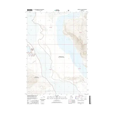
2016 Map of Cordova D-2 NW
USGS Topo · Published 2016About this map
Copper River and Bremner River dominate this wild glacial landscape, where massive waterways converge near the border of Wrangell-Saint Elias National Park and Chugach National Forest. The map illustrates a complex fluvial environment where the main river channels break into braided streams and the Nels Miller Slough. To the south, the icy expanse of the Shiels Glacier is visible, with the Shiels Glacier Trail providing a designated route through the terminal moraine and outwash plains. Another historic path, the Heney Glacier Trail, cuts across the western portion of the quadrangle, reflecting the long-established transit corridors used to navigate this corner of the Unorganized Borough. This survey provides a precise record of the shifting silt deposits and hydrological patterns where these major glacial rivers meet.
Find a feature on this map
13 named features on this map. Tap any name to fly to it.
Don’t see what you’re looking for? This feature index may not catch every label — zoom into the map to look around manually.
Map Details
Editions of this 2016 Cordova D-2 NW Map
This is the sole edition of this map. No revisions or reprints were ever made.
Other maps of this area

1948 · Cordova
USGS Topo · 1:250,000

1950 · Valdez A-3
USGS Topo · 1:63,360

1950 · Cordova D-3
USGS Topo · 1:63,360

1951 · Cordova
USGS Topo · 1:250,000

1951 · Valdez A-2
USGS Topo · 1:63,360

1952 · Valdez
USGS Topo · 1:250,000

1953 · Cordova D-3
USGS Topo · 1:63,360

1953 · Valdez A-3
USGS Topo · 1:63,360
1957 · Valdez A-2
USGS Topo · 1:63,360

1959 · Cordova D-2
USGS Topo · 1:63,360