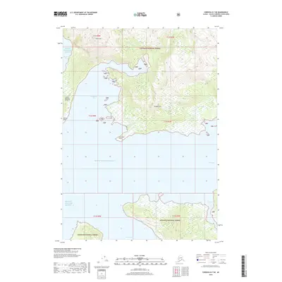
2018 Map of Cordova D-7 SW
USGS Topo · Published 2018About this map
Prince William Sound dominates this coastal landscape within the Chugach National Forest, where deep glacial inlets and steep peaks define the coastline. The Copper Mountain Peninsula extends into these waters, flanked by Boulder Bay and the sheltered Landlocked Bay. Significant elevation changes are marked by Copper Mtn and Billygoat Mtn, while numerous drainages such as Horsetail Falls Cr and Reynolds Cr feed into the sound. To the south, the map details the passage into Port Fidalgo and the cove at Two Moon Bay. The naming of Graveyard Point at the southern tip of the peninsula and Bidarka Point reflects the maritime history and traditional usage of these jagged shorelines.
Find a feature on this map
24 named features on this map. Tap any name to fly to it.
Don’t see what you’re looking for? This feature index may not catch every label — zoom into the map to look around manually.
Map Details
Editions of this 2018 Cordova D-7 SW Map
This is the sole edition of this map. No revisions or reprints were ever made.
Other maps of this area

1948 · Cordova
USGS Topo · 1:250,000

1950 · Cordova C-7
USGS Topo · 1:63,360

1950 · Cordova D-7
USGS Topo · 1:63,360

1950 · Cordova C-8
USGS Topo · 1:63,360

1951 · Cordova
USGS Topo · 1:250,000

1951 · Cordova D-8
USGS Topo · 1:63,360

1952 · Cordova D-8
USGS Topo · 1:63,360

1952 · Cordova C-8
USGS Topo · 1:63,360

1952 · Cordova D-7
USGS Topo · 1:63,360
1953 · Cordova C-7
USGS Topo · 1:63,360