
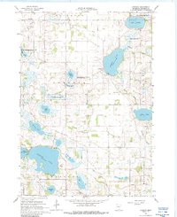
1966 Map of Cordova
USGS Topo · Published 1968About this map
Lake Volney and the surrounding wetlands of Le Sueur Park define this landscape of the upper Midwest in the mid-1960s. The region is marked by a dense network of conservation areas, including the Factor State Wildlife Management Area and the Shanghai Lake State Wildlife Management Area, indicating a mid-century shift toward managed natural resources. At the center lies the small settlement of Cordova, where the Gorman Lake Spillway and Gorman Cem sit near the shore.
Find a feature on this map
32 named features on this map. Tap any name to fly to it.
Don’t see what you’re looking for? This feature index may not catch every label — zoom into the map to look around manually.
Map Details
Editions of this 1966 Cordova Map
2 editions found
Other maps of this area

1950 · Mankato East
USGS Topo · 1:62,500

1951 · Mankato East
USGS Topo · 1:62,500

1953 · Saint Paul
USGS Topo · 1:250,000

1959 · Saint Paul
USGS Topo · 1:250,000

1965 · Cleveland
USGS Topo · 1:24,000

1965 · St Thomas
USGS Topo · 1:24,000

1966 · Montgomery
USGS Topo · 1:24,000

1966 · Waterville
USGS Topo · 1:24,000

1966 · Elysian
USGS Topo · 1:24,000

1966 · Le Center
USGS Topo · 1:24,000