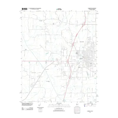
2012 Map of Corinth
USGS Topo · Published 2012About this map
Corinth serves as the focal point of this Alcorn County landscape, where the intersection of transit and local history is clearly defined. The geography is shaped by the Tuscumbia River and the engineered Tuscumbia River Canal, while the northern edge is marked by State Line Rd at the Tennessee border. Genealogists and local historians will find significant detail in the clustering of burial grounds, including the Corinth National Cem, Corinth City Cem, and Forest Hill Cem. Outside the city center, smaller communities like Wenasoga and Ruslor Junction are visible alongside specialized landmarks such as the Roscoe Turner Airport and College Hill Miller Rd. The map also illustrates the water network feeding the river system, including McElroy Cr, Kossuth Cr, and several local lakes such as Jobes Lake and Liddon Lake.
Find a feature on this map
195 named features on this map. Tap any name to fly to it.
Don’t see what you’re looking for? This feature index may not catch every label — zoom into the map to look around manually.
Map Details
Editions of this 2012 Corinth Map
This is the sole edition of this map. No revisions or reprints were ever made.
Other maps of this area

1935 · Glens
USGS Topo · 1:24,000

1936 · Kendrick
USGS Topo · 1:24,000

1936 · Michie
USGS Topo · 1:24,000

1949 · Michie
USGS Topo · 1:24,000

1950 · Corinth
USGS Topo · 1:62,500

1950 · Kendrick
USGS Topo · 1:24,000

1950 · Glens
USGS Topo · 1:24,000

1951 · Chewalla
USGS Topo · 1:24,000

1951 · Guys
USGS Topo · 1:24,000
1952 · Michie
USGS Topo · 1:24,000