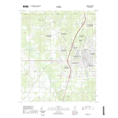
2021 Map of Corinth
USGS Topo · Published 2021About this map
Corinth serves as the central hub of this Mississippi landscape, where the intersection of historical memory and modern infrastructure is clearly defined. The city's civic core is anchored by the Alcorn County Courthouse and Alcorn Chancery Building, while its military heritage is preserved through extensive tracts of the Shiloh National Battlefield and the formal grounds of the Corinth National Cemetery. Beyond the urban center, the landscape transitions into a network of watercourses like the Tuscumbia River and Cane Creek, which are crossed by local landmarks such as Smith Bridge and Polk Levee Bridge. Small communities like Wenasoga and Guys sit near the Tennessee state line, while Ruslor Junction and College Hill mark the expansion of the area around the city's periphery. Transportation is a defining feature, ranging from the Roscoe Turner Airport to the industrial Railroad Bridge over local waters.
Find a feature on this map
175 named features on this map. Tap any name to fly to it.
Don’t see what you’re looking for? This feature index may not catch every label — zoom into the map to look around manually.
Map Details
Editions of this 2021 Corinth Map
This is the sole edition of this map. No revisions or reprints were ever made.
Other maps of this area

1935 · Glens
USGS Topo · 1:24,000

1936 · Kendrick
USGS Topo · 1:24,000

1936 · Michie
USGS Topo · 1:24,000

1949 · Michie
USGS Topo · 1:24,000

1950 · Corinth
USGS Topo · 1:62,500

1950 · Kendrick
USGS Topo · 1:24,000

1950 · Glens
USGS Topo · 1:24,000

1951 · Chewalla
USGS Topo · 1:24,000

1951 · Guys
USGS Topo · 1:24,000
1952 · Michie
USGS Topo · 1:24,000