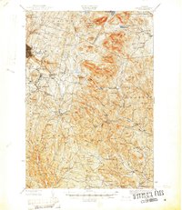
1947 Map of Corinth
USGS Topo · Published 1947About this map
The granite-carved hills of Orange County define this mid-century survey, where the industry of Millstone Hill and Cobble Hill shaped the growth of specialized settlements like Websterville, Graniteville, and East Barre. These industrial clusters are contrasted by the rural landscape to the south and east, where small crossroads like Cookville, Goose Green, and Riders Corners supported a distributed farming community. The map records a dense network of local education and faith, identifying numerous country institutions such as Newman Sch, Pike Hill Sch, and Miles Sch, alongside established burial grounds like Wilson Cem and Maple Hill Cem.
Find a feature on this map
99 named features on this map. Tap any name to fly to it.
Don’t see what you’re looking for? This feature index may not catch every label — zoom into the map to look around manually.
Map Details
Editions of this 1947 Corinth Map
This is the sole edition of this map. No revisions or reprints were ever made.
Other maps of this area
1896 · Strafford
USGS Topo · 1:62,500
1919 · Royalton
USGS Topo · 1:62,500
1919 · Montpelier
USGS Topo · 1:62,500
1921 · Montpelier
USGS Topo · 1:62,500
1922 · Barre
USGS Topo · 1:48,000
1924 · Barre
USGS Topo · 1:62,500
1924 · Randolph
USGS Topo · 1:48,000
1926 · Randolph
USGS Topo · 1:62,500
1931 · Mt. Cube
USGS Topo · 1:62,500
1931 · Woodsville
USGS Topo · 1:48,000