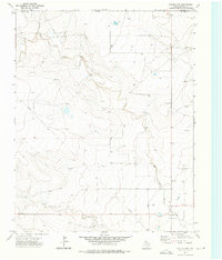
1973 Map of Corlena NW
USGS Topo · Published 1976About this map
Oklahoma and Texas meet at the northern edge of this high-plains landscape, where the irregular path of East Rita Blanca Creek cuts through the topography of Dallam County. Surveyed in the early 1970s, the map illustrates a rural environment defined by sparse water sources and essential infrastructure. The drainage basin is marked by numerous Well sites, indicating the importance of groundwater for the region's agricultural or ranching needs. Human presence is evidenced by a network of utility and transport markers, including a Pipeline that traverses the terrain and a Jeep Trail winding through the south-central sections. Industrial activity appears in the form of a Gravel Pit and a power Substa located near the southern boundary, highlighting the localized extraction and utility distribution systems that supported the area during this era.
Find a feature on this map
8 named features on this map. Tap any name to fly to it.
Don’t see what you’re looking for? This feature index may not catch every label — zoom into the map to look around manually.
Map Details
Editions of this 1973 Corlena NW Map
This is the sole edition of this map. No revisions or reprints were ever made.
Other maps of this area

1954 · Dalhart
USGS Topo · 1:250,000

1958 · Dalhart
USGS Topo · 1:250,000

1962 · Dalhart
USGS Topo · 1:250,000

1969 · Felt SW
USGS Topo · 1:24,000

1969 · Felt
USGS Topo · 1:24,000

1970 · Texline South
USGS Topo · 1:24,000

1970 · Texline North
USGS Topo · 1:24,000

1972 · Rardin Hill
USGS Topo · 1:24,000

1973 · Buffalo Springs
USGS Topo · 1:24,000

1973 · Corlena
USGS Topo · 1:24,000