
1969 Map of Felt
USGS Topo · Published 1971About this map
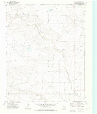
Felt stands as the primary settlement on this High Plains landscape during the late 1960s, positioned along the highway corridor of U. S. 56 64. The area is characterized by the broad drainage systems of the North Canadian River and its southern tributaries, including Cieneguilla Creek and Aqua Fria Creek. The map documents the rural infrastructure of the Oklahoma Panhandle, where the terrain is marked by township sections and the notable elevated areas of Wheeless and Gresham. A scatter of wells across the plains indicates the region's reliance on groundwater for agricultural and domestic use. The survey also captures the precise boundary between Cimarron and Dallam counties, where the state line separates Oklahoma and Texas. Local industry is represented by a Gravel Pit located near the southern watercourses, reflecting the small-scale extraction typical of the era's local economy.
Find a feature on this map
11 named features on this map. Tap any name to fly to it.
Don’t see what you’re looking for? This feature index may not catch every label — zoom into the map to look around manually.
Map Details
Editions of this 1969 Felt Map
This is the sole edition of this map. No revisions or reprints were ever made.
Other maps of this area

1954 · Dalhart
USGS Topo · 1:250,000

1958 · Dalhart
USGS Topo · 1:250,000

1962 · Dalhart
USGS Topo · 1:250,000

1969 · Felt SW
USGS Topo · 1:24,000

1969 · Boise City NW
USGS Topo · 1:24,000

1969 · Boise City SW
USGS Topo · 1:24,000

1969 · Wheeless
USGS Topo · 1:24,000

1969 · Felt NE
USGS Topo · 1:24,000

1973 · Buffalo Springs
USGS Topo · 1:24,000
1973 · Corlena NW
USGS Topo · 1:24,000