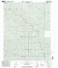
1998 Map of Corlena NW
USGS Topo · Published 2001About this map
Rita Blanca National Grassland dominates this high plains landscape at the intersection of the Texas Panhandle and Oklahoma. The terrain is defined by the winding course of East Rita Blanca Creek, which cuts through the plateau, creating a network of draws and elevations. This 1990s revision reflects a landscape dedicated to conservation and utility, managed under the Cibola National Forest. Human activity is sparsely marked by infrastructure such as a Pipeline, a Substation, and a Gravel Pit. The map captures the exact boundary line where Cimarron County, Oklahoma, meets Dallam County, Texas, providing a clear look at the jurisdictional divisions of the Great Plains during this era.
Find a feature on this map
8 named features on this map. Tap any name to fly to it.
Don’t see what you’re looking for? This feature index may not catch every label — zoom into the map to look around manually.
Map Details
Editions of this 1998 Corlena NW Map
This is the sole edition of this map. No revisions or reprints were ever made.
Other maps of this area

1954 · Dalhart
USGS Topo · 1:250,000

1958 · Dalhart
USGS Topo · 1:250,000

1962 · Dalhart
USGS Topo · 1:250,000

1969 · Felt SW
USGS Topo · 1:24,000

1969 · Felt
USGS Topo · 1:24,000

1970 · Texline South
USGS Topo · 1:24,000

1970 · Texline North
USGS Topo · 1:24,000

1972 · Rardin Hill
USGS Topo · 1:24,000

1973 · Buffalo Springs
USGS Topo · 1:24,000

1973 · Corlena
USGS Topo · 1:24,000