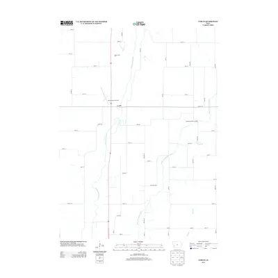
2013 Map of Corley
USGS Topo · Published 2013About this map
The W Nishnabotna River and its various tributaries, including the E Br W Nishnabotna River and Bedell Cr, dominate this agricultural landscape in the 2010s. The settlement of Corley sits at the intersection of a well-defined grid of section roads and the larger regional highway. This area serves as a transport and utility hub for the surrounding countryside, featuring the Harlan Municipal Airport and the distinctively named Nishnabotna River Bridge. Small waterways like Dutch Br wind through the fields, illustrating the drainage patterns that have shaped Iowa farming for generations. The map also identifies the Shelby County Farm, a notable local landmark that speaks to the county’s civic and agricultural history.
Find a feature on this map
37 named features on this map. Tap any name to fly to it.
Don’t see what you’re looking for? This feature index may not catch every label — zoom into the map to look around manually.
Map Details
Editions of this 2013 Corley Map
This is the sole edition of this map. No revisions or reprints were ever made.
Other maps of this area

1954 · Omaha
USGS Topo · 1:250,000

1957 · Omaha
USGS Topo · 1:250,000

1958 · Omaha
USGS Topo · 1:250,000

1963 · Avoca NW
USGS Topo · 1:24,000

1963 · Avoca
USGS Topo · 1:24,000

1971 · Walnut
USGS Topo · 1:24,000

1978 · Panama
USGS Topo · 1:24,000

1978 · Corley
USGS Topo · 1:24,000

1978 · Prairie Rose Lake
USGS Topo · 1:24,000
1978 · Harlan
USGS Topo · 1:24,000