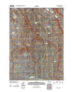
2011 Map of Corn Lake
USGS Topo · Published 2011About this map
High-desert water management defines this 2011 survey of Harney County, Oregon, where a network of reservoirs and waterholes suggests a landscape vital for ranching and livestock. Named features such as Mikes Draw Reservoir, Order Reservoir, and Taylor Reservoir reflect the intensive infrastructure required to capture seasonal runoff in this arid environment. The topography is marked by distinct basaltic features, including Eagle Butte and the curved formations of The Horseshoes and Horseshoe Ridge. Small, isolated lakes like Corn Lake and Eagle Butte Lake dot the basin floors, while the southern end of the quadrangle shows specialized points of interest like the West Last Chance Waterhole near the Last Chance Lakes. Local transit is limited to unpaved routes like Bacon Camp Rd and Corn Lake Rd, which provide access through this remote stretch of the Oregon high desert.
Find a feature on this map
16 named features on this map. Tap any name to fly to it.
Don’t see what you’re looking for? This feature index may not catch every label — zoom into the map to look around manually.
Map Details
Editions of this 2011 Corn Lake Map
This is the sole edition of this map. No revisions or reprints were ever made.
Other maps of this area

1955 · Adel
USGS Topo · 1:250,000

1957 · Adel
USGS Topo · 1:250,000

1958 · Adel
USGS Topo · 1:250,000

1962 · Adel
USGS Topo · 1:250,000

1966 · Rabbit Hills NE
USGS Topo · 1:24,000

1966 · Rabbit Hills NW
USGS Topo · 1:24,000

1967 · Bluejoint Lake West
USGS Topo · 1:24,000
1971 · Corporation Rim
USGS Topo · 1:24,000
1971 · Red Bank Lakes
USGS Topo · 1:24,000
1984 · Turpin Knoll
USGS Topo · 1:24,000