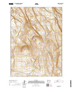
2020 Map of Corn Lake
USGS Topo · Published 2020About this map
Horseshoe Rim and the broad expanse of Dry Valley dominate this High Desert landscape in Harney County. This modern survey illustrates a remote corner of Oregon defined by steep escarpments and intermittent watercourses like Juniper Cr. The topography is marked by significant elevation changes, particularly where Macs Draw cuts through the high plateaus in the northeast. Access to this isolated terrain is limited to a network of forest development roads, including Nat For Dev Rd 6130 and the bluntly named Nasty Flat Rd. While devoid of permanent settlements, the map provides a precise record of the Public Land Survey System boundaries, specifically within Townships 31 and 32 South, which is essential for identifying specific land parcels in this arid cattle-country region.
Find a feature on this map
12 named features on this map. Tap any name to fly to it.
Don’t see what you’re looking for? This feature index may not catch every label — zoom into the map to look around manually.
Map Details
Editions of this 2020 Corn Lake Map
This is the sole edition of this map. No revisions or reprints were ever made.
Other maps of this area

1955 · Adel
USGS Topo · 1:250,000

1957 · Adel
USGS Topo · 1:250,000

1958 · Adel
USGS Topo · 1:250,000

1962 · Adel
USGS Topo · 1:250,000

1966 · Rabbit Hills NE
USGS Topo · 1:24,000

1966 · Rabbit Hills NW
USGS Topo · 1:24,000

1967 · Bluejoint Lake West
USGS Topo · 1:24,000
1971 · Corporation Rim
USGS Topo · 1:24,000
1971 · Red Bank Lakes
USGS Topo · 1:24,000
1984 · Turpin Knoll
USGS Topo · 1:24,000