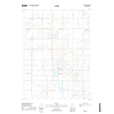
2018 Map of Cornelia
USGS Topo · Published 2018About this map
Lake Cornelia and Elm Lake anchor this agricultural landscape in Wright County, where a network of section-line roads like Co Rd R38 and Page Ave connects the small settlement of Cornelia to the surrounding prairie. The northern edge of the survey reveals Morse Lake and the Ringsaker Cem, providing a clear record of local family history and land use in the early twenty-first century. The Iowa River winds through the eastern portion of the map, passing through the wooded terrain of Pikes Timber and under the Cornelia-Lake Bridge. This map captures the distinct water-management patterns of the region, from the natural glacial lakes to the channelized stretches of White Fox Cr and Eagle Cr, showing how water defines the boundaries of both modern agriculture and local recreation.
Find a feature on this map
39 named features on this map. Tap any name to fly to it.
Don’t see what you’re looking for? This feature index may not catch every label — zoom into the map to look around manually.
Map Details
Editions of this 2018 Cornelia Map
This is the sole edition of this map. No revisions or reprints were ever made.
Other maps of this area

1954 · Waterloo
USGS Topo · 1:250,000

1955 · Waterloo
USGS Topo · 1:250,000

1972 · Kanawha SE
USGS Topo · 1:24,000

1972 · Cornelia
USGS Topo · 1:24,000

1972 · Kanawha
USGS Topo · 1:24,000

1972 · Olaf
USGS Topo · 1:24,000

1972 · Belmond
USGS Topo · 1:24,000
1972 · Goodell
USGS Topo · 1:24,000

1978 · Holmes
USGS Topo · 1:24,000

1978 · Clarion
USGS Topo · 1:24,000