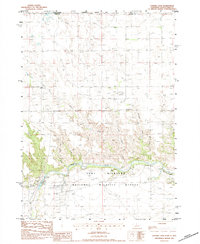
1983 Map of Cornell Dam
USGS Topo · Published 1984About this map
The Niobrara River flows through a landscape defined by conservation and early infrastructure on this 1983 provisional map. The Fort Niobrara National Wildlife Refuge occupies the southern half of the sheet, where the Refuge Headquarters is situated near the riverbanks. The presence of the Cornell Dam, complete with its Spillway and Power Plant, indicates the historical integration of water power and management within this protected area. Tributaries such as Big Beaver Creek and Crooked Creek carve through the northern plains, leading toward the Rosebud Indian Res at the Nebraska and South Dakota border. This survey captures a specific era of federal land oversight and hydrological control, documenting the roads and structures supporting both the refuge and the nearby Fort Falls area.
Find a feature on this map
17 named features on this map. Tap any name to fly to it.
Don’t see what you’re looking for? This feature index may not catch every label — zoom into the map to look around manually.
Map Details
Editions of this 1983 Cornell Dam Map
This is the sole edition of this map. No revisions or reprints were ever made.
Other maps of this area

1950 · Sparks
USGS Topo · 1:62,500

1950 · Valentine
USGS Topo · 1:62,500

1955 · Martin
USGS Topo · 1:250,000

1957 · Valentine
USGS Topo · 1:250,000

1958 · Martin
USGS Topo · 1:250,000

1959 · Valentine
USGS Topo · 1:250,000

1982 · Olsonville SE
USGS Topo · 1:24,000

1982 · Hidden Timber SE
USGS Topo · 1:24,000
1982 · Littleburg
USGS Topo · 1:24,000

1982 · Mission
USGS Topo · 1:100,000