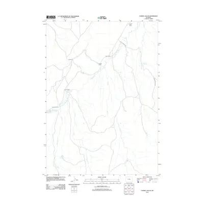
2012 Map of Cornell Gulch
USGS Topo · Published 2012About this map
The Nowood River winds through this section of Washakie County, providing a vital water source for high-plains ranching operations like the Nowood Ranch and Lone Tree Ranch. The landscape is defined by its drainage systems, including the namesake Cornell Gulch and several seasonal creeks that feed into the river valley. Infrastructure in this sparsely populated area is centered on livestock movement and aviation, notably the Cherry Creek Stock Dr and the Orchard Ranch Airport. This 2012 survey illustrates the continued importance of water management in the arid Wyoming interior, with features such as Orchard Reservoir and Berger Spring marking essential resources. The network of local roads, such as Blue Bank Rd and Upper Nowood Rd, connects these isolated homesteads across a terrain etched by Split Rock Cr, Trout Cr, and Bear Cr.
Find a feature on this map
15 named features on this map. Tap any name to fly to it.
Don’t see what you’re looking for? This feature index may not catch every label — zoom into the map to look around manually.
Map Details
Editions of this 2012 Cornell Gulch Map
This is the sole edition of this map. No revisions or reprints were ever made.
Other maps of this area

1952 · Cottonwood Pass
USGS Topo · 1:24,000

1952 · Sioux Pass
USGS Topo · 1:24,000

1952 · Badwater NE
USGS Topo · 1:24,000

1952 · Battle Mountain
USGS Topo · 1:24,000

1955 · Arminto
USGS Topo · 1:250,000

1958 · Arminto
USGS Topo · 1:250,000

1962 · Arminto
USGS Topo · 1:250,000

1966 · Sand Point
USGS Topo · 1:24,000

1967 · Mahogany Butte
USGS Topo · 1:24,000
1967 · Cornell Gulch
USGS Topo · 1:24,000