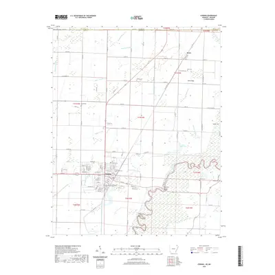
2020 Map of Corning
USGS Topo · Published 2020About this map
Corning serves as a focal point of this northeastern Arkansas landscape, where the Clay County Courthouse Western District stands near a grid of established streets like W Main St and W Elm St. To the north, the small settlement of Moark sits along the Missouri border, positioned near Moark Ridge and Moark Cem. The geography is defined by an extensive network of drainage features such as the Townsend Lateral, Hobson Lateral, and Middle Cr Ditch, reflecting the region's managed wetlands and agricultural engineering.
Find a feature on this map
96 named features on this map. Tap any name to fly to it.
Don’t see what you’re looking for? This feature index may not catch every label — zoom into the map to look around manually.
Map Details
Editions of this 2020 Corning Map
This is the sole edition of this map. No revisions or reprints were ever made.
Other maps of this area

1935 · Acorn
USGS Topo · 1:62,500

1935 · Rector
USGS Topo · 1:62,500

1935 · Knobel
USGS Topo · 1:62,500

1935 · Harviell
USGS Topo · 1:62,500

1940 · Naylor
USGS Topo · 1:62,500

1941 · Knobel
USGS Topo · 1:62,500

1944 · Naylor
USGS Topo · 1:62,500

1957 · Poplar Bluff
USGS Topo · 1:250,000

1958 · Rector
USGS Topo · 1:62,500

1959 · Poplar Bluff
USGS Topo · 1:250,000